“Colditz was situated in the middle of the triangle formed by the three great cities of Leipzig, Dresden, and Chemnitz, in the heart of the German Reich and four hundred miles from any frontier not directly under the Nazi heel.”

“The Castle was built by Augustus the Strong, an ancient King of Saxony and Poland, who was reputed to have had three hundred and sixty-five wives, one for every day of the year. It had seen many battles and sieges in a long history, and the present name, Schloss Colditz, testified, not to it’s origin, but to a time when it was under Polish domination. The ‘itz’ is a Slavonic not a Tuetonic or Saxon ending. The original spelling was Koldyeze.”
“It was built on the top of a high cliff promontory that jutted out over the River Mulde at a confluence with a tributary stream. The outside walls were on an average seven feet thick, and the inner courtyard of the castle was about two hundred and fifty feet above the river level.” “The River Mulde, we later learned, was a tributary of the Elbe, into which it flowed forty miles to the north.”
“In such a castle, through the centuries, everything had happened and anything might happen again. To friendly peasants and trades people in the houses nestling beneath its shadows it may have signified protection and home, but to enemies from a distant country such a castle struck the note of doom and was a sight to make the bravest quail. Indeed, it was built with this end in view. Being about one thousand years old, although partly ruined, built over and altered many times, its inherent strength had preserved it from destruction through the centuries.”
‘The Colditz Story’ by P.R.Reid, M.B.E, M.C.
So where exactly is Colditz?:
![]()

The map above shows the current borders between the European States. At the outbreak of WW2 the German/Polish borders were somewhat different. Even on a current map one can see Germany is centrally located in Europe.

Above, a poor quality visually – but a fascinating map. Colditz, on an East West axis, was in the heart of Germany. The escapees would normally seek to travel north to cross to neutral Sweden via a Baltic port such as Danzig (e.g. Dominic Bruce’s attempt), or travel south west to neutral Switzerland (such as Neave or Reid). The ‘Protectorate’ (part of Czechoslovakia) was to be avoided. Some, such as Sinclair & Best, headed to western Europe, e.g the Netherlands.

Above, a modern day map of Germany. Colditz is in the State of Saxony. The town now lies in the far east of Germany and for many years was in the DDR and is located south east of Leipzig.

The white cross marks the position of Colditz Town. Positioned in the Leipzig, Dresden & Chemnitz triangle.

Above, a map of the surrounding area setting the castle in context of the town and the forest.

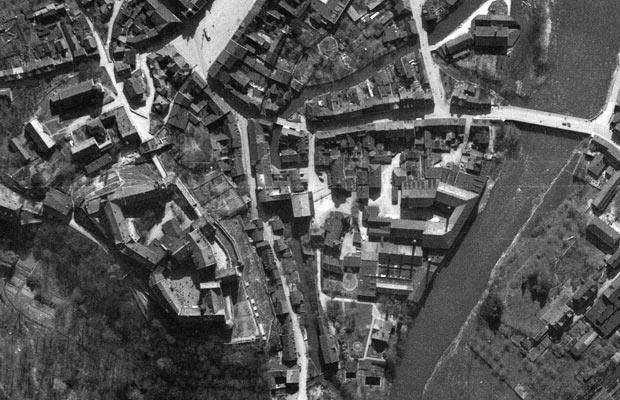
Above, a Satellite view of Colditz Town. The former ‘Adolf Hitler’ Bridge can be clearly seen. So too can the Castle with the Tiergarten to it’s right and the Town Square below.
Above, a wonderful aerial recce photo shows the POWs in the yard – and vehicles and pedastrians on the bridge.
